קובץ:GOES-13 2 Jan 2014 1745z satellite.png

גודל התצוגה המקדימה הזאת: 800 × 450 פיקסלים. רזולוציות אחרות: 320 × 180 פיקסלים | 640 × 360 פיקסלים | 1,024 × 576 פיקסלים | 1,280 × 720 פיקסלים | 1,920 × 1,080 פיקסלים.
לקובץ המקורי (1,920 × 1,080 פיקסלים, גודל הקובץ: 1.1 מ"ב, סוג MIME: image/png)
זהו קובץ שמקורו במיזם ויקישיתוף. תיאורו בדף תיאור הקובץ המקורי (בעברית) מוצג למטה
ויקישיתוף הוא מאגר תמונות וקובצי מדיה חופשיים. אתם יכולים לעזור. |
תקציר
| תיאור |
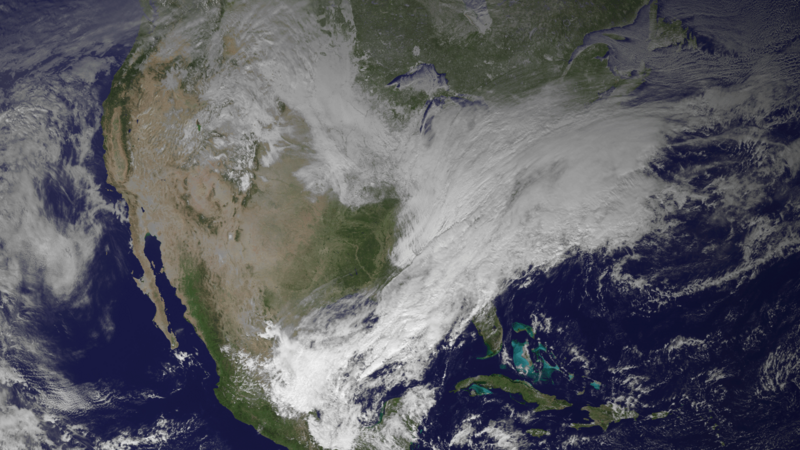
English: A GOES-13 satellite image captured at 17:45 UTC on January 2, 2014, depicting an ongoing blizzard across portions of the Ohio River Valley and the Northeast United States as cold air from Canada moves across warm air from the Gulf of Mexico. |
| תאריך יצירה | |
| מקור | http://www.nnvl.noaa.gov/images/high_resolution/1478v1_20140102-GOES-Blizzard.png |
| יוצר | National Oceanic and Atmospheric Administration |
רישיון
This image is in the public domain because it contains materials that originally came from the U.S. National Oceanic and Atmospheric Administration, taken or made as part of an employee's official duties.
|
היסטוריית הקובץ
ניתן ללחוץ על תאריך/שעה כדי לראות את הקובץ כפי שנראה באותו זמן.
| תאריך/שעה | תמונה ממוזערת | ממדים | משתמש | הערה | |
|---|---|---|---|---|---|
| נוכחית | 08:34, 8 בינואר 2014 | | 1,080 × 1,920 (1.1 מ"ב) | Wxtrackercody | User created page with UploadWizard |
שימוש בקובץ
הדף הבא משתמש בקובץ הזה:
שימוש גלובלי בקובץ
אתרי הוויקי השונים הבאים משתמשים בקובץ זה:
- שימוש באתר de.wikipedia.org
- שימוש באתר en.wikipedia.org
- שימוש באתר es.wikipedia.org
- שימוש באתר fr.wikipedia.org
- שימוש באתר he.wikipedia.org
- שימוש באתר id.wikipedia.org
- שימוש באתר nl.wikipedia.org
- שימוש באתר vi.wikipedia.org
- שימוש באתר www.wikidata.org
- שימוש באתר zh.wikipedia.org