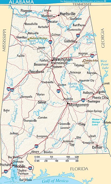
קובץ:Map of Alabama terrain NA.jpg

גודל התצוגה המקדימה הזאת: 362 × 599 פיקסלים. רזולוציות אחרות: 145 × 240 פיקסלים | 290 × 480 פיקסלים | 810 × 1,340 פיקסלים.
לקובץ המקורי (810 × 1,340 פיקסלים, גודל הקובץ: 244 ק"ב, סוג MIME: image/jpeg)
היסטוריית הקובץ
ניתן ללחוץ על תאריך/שעה כדי לראות את הקובץ כפי שנראה באותו זמן.
| תאריך/שעה | תמונה ממוזערת | ממדים | משתמש | הערה | |
|---|---|---|---|---|---|
| נוכחית | 15:39, 1 באוקטובר 2007 |  | 1,340 × 810 (244 ק"ב) | Wikid77 | enlarged "Cheaha" & "Natural Bridge"; enlarged 15 names; added "Fairhope" |
| 21:12, 11 באוגוסט 2007 |  | 1,340 × 810 (243 ק"ב) | Wikid77 | reduced map height 5% to magnify description-page image 5% (article map same width); clarified some "-ville" suffixes | |
| 15:11, 11 באוגוסט 2007 |  | 1,410 × 810 (252 ק"ב) | Wikid77 | narrowed map to magnify 4% (people notice 2%+), enlarged scale (miles+20% km+10%) "Selma" 40%; clarified many names; split "West/Point" lake | |
| 08:33, 10 באוגוסט 2007 |  | 1,410 × 840 (252 ק"ב) | Wikid77 | enlarged "Selma" 30% and Interstate icons by 10%; clarified other town names | |
| 07:03, 10 באוגוסט 2007 |  | 1,410 × 840 (251 ק"ב) | Wikid77 | added "Natural Bridge" and enlarged "Selma"/"Cheaha" 20%; in "Birmingham" split "r/m"; aligned "Haleyville" / "Opelika"; clarified "Birmingham" roads | |
| 08:57, 25 ביולי 2007 |  | 1,410 × 840 (250 ק"ב) | Wikid77 | labeled "TENNESSEE" & clarify/copy I-10 icon @Florida; darken Birmingham, Huntsville, Tuscaloosa, Dothan, Mobile. | |
| 15:09, 24 ביולי 2007 |  | 1,410 × 840 (249 ק"ב) | Wikid77 | {{Information| | Description=Map of the U.S. state of Alabama, showing terrain features: hills, lakes, rivers, roads and major towns, in quick photographic format (JPEG) to highlight terrain features. | Source=[http://www.nationalatlas.gov Nationa |
שימוש בקובץ
הדף הבא משתמש בקובץ הזה:
שימוש גלובלי בקובץ
אתרי הוויקי השונים הבאים משתמשים בקובץ זה:
- שימוש באתר az.wikipedia.org
- שימוש באתר bo.wikipedia.org
- שימוש באתר da.wikipedia.org
- שימוש באתר de.wikivoyage.org
- שימוש באתר el.wikipedia.org
- שימוש באתר en.wikipedia.org
- שימוש באתר fa.wikipedia.org
- שימוש באתר fi.wikipedia.org
- שימוש באתר gag.wikipedia.org
- שימוש באתר id.wikipedia.org
- שימוש באתר io.wikipedia.org
- שימוש באתר ja.wikipedia.org
- שימוש באתר kk.wikipedia.org
- שימוש באתר lt.wikipedia.org
- שימוש באתר mk.wikipedia.org
- שימוש באתר ml.wikipedia.org
- שימוש באתר nl.wikipedia.org
- שימוש באתר nl.wiktionary.org
- שימוש באתר no.wikipedia.org
- שימוש באתר pam.wikipedia.org
- שימוש באתר pl.wikipedia.org
- שימוש באתר pt.wikipedia.org
- שימוש באתר ru.wikipedia.org
- שימוש באתר sd.wikipedia.org
- שימוש באתר simple.wikipedia.org
- שימוש באתר sw.wikipedia.org
- שימוש באתר szl.wikipedia.org
- שימוש באתר tr.wikipedia.org
- שימוש באתר uk.wikipedia.org
- שימוש באתר vi.wikipedia.org
- שימוש באתר zh.wikipedia.org
